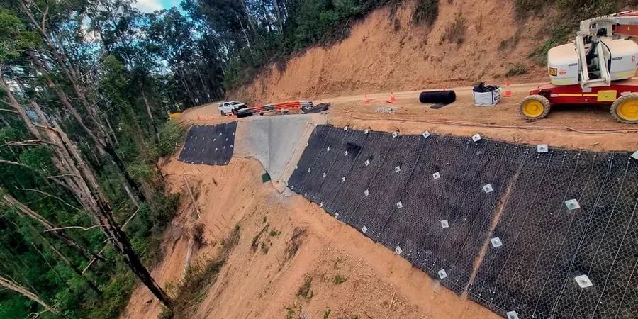
Wollongong sits between a steep escarpment and the Tasman Sea, a geography that creates some of the most landslide-prone urban terrain in New South Wales. Over 500 mapped landslides exist across the Illawarra region, many concentrated in the northern suburbs where the Hawkesbury Sandstone meets colluvial clays. Every winter storm season reactivates old slip planes and triggers debris flows that threaten property and infrastructure. A compliant slope stability analysis is not optional here—it is a standard requirement for DA submissions on any site with a gradient exceeding 15 degrees. The analysis quantifies the factor of safety under both static and seismic loading, using parameters derived from site-specific investigation rather than conservative textbook defaults. For sites where weak foundation soils compound the slope risk, we complement the investigation with in-situ permeability testing to model pore pressure response during heavy rainfall events.
A slope that appears stable after three dry years can fail catastrophically during a single sustained rain event—residual strength governs the long-term risk.
Site-specific factors
A 14-unit townhouse development in the Balgownie foothills encountered a 4-metre-thick colluvial layer overlying extremely weathered sandstone. Initial geotechnical investigation identified a pre-existing shear surface at 3.8 metres depth, dipping 22 degrees toward the proposed building pad. The developer had already secured construction finance based on a generic desk study that classified the site as low risk. Detailed stability modelling using residual friction angles of 18 degrees showed a static factor of safety below 1.2, dropping to 0.9 under the design storm event. The DA was suspended pending a peer-reviewed slope stability analysis. The final solution required a row of bored piles socketed below the shear zone, a subsurface drainage blanket, and ongoing inclinometer monitoring—adding AU$340,000 to the project cost. The lesson in Wollongong is unambiguous: escarpment sites demand site-specific residual strength testing before design assumptions are locked in.
Quick answers
What is the typical cost of a slope stability analysis for a residential DA in Wollongong?
For a single residential lot on a moderate slope, budget between AU$1,720 and AU$5,670 depending on whether drilling and laboratory testing are required. A desktop analysis using existing borehole data sits at the lower end; a full investigation with core drilling, triaxial testing, and limit equilibrium modelling approaches the upper range. Complex sites with active landslides or deep shear surfaces will exceed this.
Which Wollongong suburbs trigger a mandatory slope stability assessment?
Wollongong City Council's DCP 2009 requires a geotechnical slope stability report for any development on land with a gradient steeper than 15% (approximately 8.5 degrees). This captures much of Balgownie, Mount Keira, Mount Ousley, Woonona Heights, and the escarpment fringe suburbs. Sites within the mapped landslide hazard zone—covering significant portions of the northern suburbs—face additional scrutiny regardless of gradient.
How long does a complete slope stability investigation take?
A full investigation with drilling, instrumentation installation, laboratory testing, and analysis typically takes 4–6 weeks. Allow an additional week if the report requires peer review for a contentious DA. Desktop studies using existing data can be completed in 1–2 weeks. The critical path is usually the triaxial testing, which requires saturated sample consolidation that cannot be rushed.
What is the difference between peak and residual shear strength in slope analysis?
Peak strength represents the maximum shear resistance of intact material and applies to slopes that have never failed. Residual strength is the lower, constant value reached after large displacements have occurred along a shear surface. In Wollongong's escarpment colluvium, many slopes contain pre-existing shear planes from ancient landslides—these must be analysed using residual parameters. Using peak strength on a reactivated landslide produces an unconservative factor of safety and is the single most common error we see in rejected DA reports.